 Understanding Natural Heritage Area Reports
County Natural Heritage Inventory (CNHI) reports provide ecological information about each county and all Natural Heritage Areas (NHAs) that occur in that county. Individual NHA reports are also available as separate PDF documents, which can be viewed and downloaded by navigating to the NHA of interest in the “Natural Heritage Area: Core Habitat” layer of the Conservation Explorer Map. A list of the NHAs and site descriptions is available here.
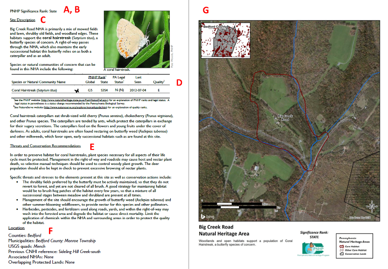
NHA reports include the following sections: Site Name, Site Ranking, Site Description, Species Table, Threats and Conservation Recommendations, Location, and Map. Each of these sections are described in detail, below. A sample NHA report is also pictured here, with each individual section labeled.

Site Name: Each site is given a name, usually based on a major landmark within or near the site, such as a road, body of water, or topographical feature.
Site Ranking: Sites are assigned a rank of either “local”, “state”, “regional”, or “global,” representing the site’s overall importance for biodiversity. These are official ranks, based on standard methods, and provide an important view of the site’s importance. In Pennsylvania, there are very few locally-important NHAs (approximately 1% of NHAs), but ~ 60% of our NHAs are important at the state level, and the remaining NHA’s are split relatively evenly between regional and global importance. To calculate a site score and assign a rank, the global and state ranks of each species or natural community of concern that are present are weighted by the element occurrence (EO) quality ranks, which are explained below. Scores are then summed for each site to produce an overall score and assign each NHA a rank.
- Local sites have importance to biological diversity at the county scale, but may not be known to contain species of concern or state-significant natural communities. These sites are often recognized because of their relative size, undisturbed character, or proximity to areas of known significance, and may be revisited in the future for further biodiversity surveys.
- State sites are important for the biological diversity and ecological integrity at the state (subnational) scale. These sites have occurrences of elements of biodiversity with lower ranks, smaller populations or extent, or generally lower biodiversity scores than Global or Regional ranked areas.
- Regional sites are important for maintaining a representation of species or communities of concern in the greater Northeast /mid-Atlantic region. Sites in this category generally contain one or more occurrences of species of global concern (e.g., G3) or higher concentrations of species of lower significance.
- Global sites have global importance for biological diversity. Sites in this category generally contain one or more occurrences of species of global concern (e.g., G2 and G1) or larger concentrations of species of lower significance. Pennsylvania has a primary role to maintain these elements (e.g., most of the known occurrences are within Pennsylvania).
Site Description: This section includes a brief description of the site, including the general location of the site, the types of habitats it contains, and the communities or species of conservation concern present. These descriptions are typically based on field notes taken by the biologists who survey the site.
Species Table: Within each NHA site account, a table lists each species or community of concern present at the site. Within these tables will be the scientific and common name of the species or natural community, its state and global conservation rank as assigned by NatureServe, Pennsylvania’s legal status, the last time it was seen during a survey of this site, and the estimated quality of the population or community. In general, species are only listed within the species table if they are listed at a state-rank level 3 or higher—that is, if they are considered Vulnerable in the state of Pennsylvania. Species that are ranked at an S4 or S5 (Apparently Secure, or Secure in Pennsylvania) are generally not listed in the species table, even if they are present at the site. Some of these less threatened species, however, may be discussed in the site description if they are relatively uncommon, are an indicator of a particular community or habitat type, or play an important ecological role at the site (for example, are the food plant for another species of concern). Species are also generally only listed in the species table if they have been observed at the site in the last 25 years, and if their presence and identification have been approved by PNHP biologists. Species which have not been seen within this time period, but were once present, are considered “historic” records at that site.
Some species in Pennsylvania are considered to be sensitive and cannot be named specifically when present at a site. These are simply listed as a “sensitive species of concern” in the species table. The reason for species sensitivity varies depending on the particular organism, but many species that fall into this category are those which are threatened by collection, hunting or are highly sensitive to disturbances. These species are not named in an effort to protect them from further human disturbances.
Threats and Conservation Recommendations: This section of each NHA site account provides a summary of known current or potential threats to the biodiversity at the site, as well as general management recommendations to address these issues. It is formatted as a brief overview of the issues, followed by a more detailed list of individual threats and management actions. This information is based on a combination of site-specific information gathered during site visits by PNHP biologists, as well as known best practices from the conservation and restoration literature related to the species and communities present at the site.
Location: This section of each NHA report helps to clarify where each site is located. Information includes the counties and municipalities that overlap with the site, the USGS map quadrangles within which it is found, any previous names the site was known by, any Associated NHAs (that is, other nearby sites which share ecological habitat that the focal NHA species also may rely on), and whether or not there currently are protected lands which overlap with the site.
References: Any sources that were cited within the text of the NHA are listed in this section, to allow for further reading about any particular aspects of the site that warrant more attention but cannot be explained fully within the brief report. For example, references listed in this section might include handbooks published by the state describing best practices for managing particular types of communities, fact sheets describing how to recognize or control a particular invasive species threatening the site, or a research paper explaining important aspects of the biology of a species of concern. Whenever possible, these references are selected to be freely available online to all users.
Map: The map associated with each NHA site account provides an image of the NHA Core Habitat, drawn over an aerial photo of the landscape. In the top left corner of each map image is an inset outline of the county showing where the site is located. Protected lands are represented in each map as shaded areas. Other nearby NHAs are also included in the map, if visible within the map extent. To improve readability, we include only the NHA core habitat on these maps.
Example Uses: NHA site accounts provide users with detailed information describing the location and condition of known habitats for biodiversity. This information supports land managers interested in developing site conservation plans. County or municipal planners can use NHA site accounts to gain a better understanding of the distribution and quality of ecological resources in a region of interest, which can be key for developing environmentally sustainable development plans. Organizations developing regional greenway plans can also use NHA site accounts to identify the intact habitat patches that would benefit the most from an increase in ecological connectivity.


