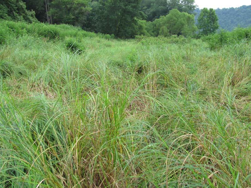
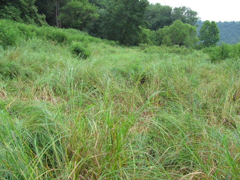
Hairy-fruit Sedge (Carex trichocarpa) Floodplain Wetland
System: Palustrine
Subsystem: Herbaceous
PA Ecological Group(s): River Floodplain
Global Rank:G4
![]() rank interpretation
rank interpretation
State Rank: S4
General Description
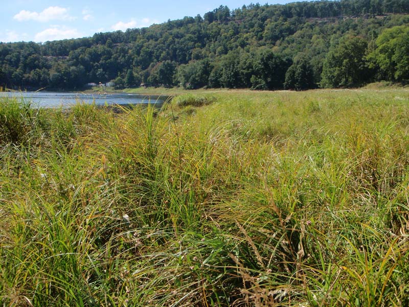
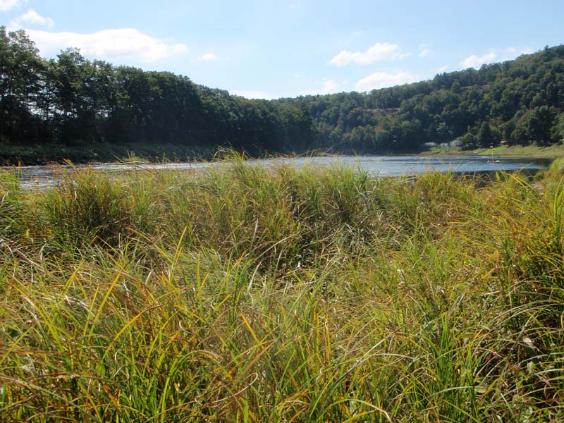
This community occurs in small patches on floodplain edges, deposition bars, and islands where tree canopy is lacking, on medium- to large-sized rivers in the Allegheny, Susquehanna, and Delaware River Basins. This community commonly occurs on low flats associated with the active floodplains, either directly adjacent to the channel or in association with backwater depressions and slough, and is routinely flooded during most high-water events. This community also occurs on the lower portion of sloping shorelines of the Upper Delaware River, often giving the appearance of an extensive “lawn.” High energy flood-scour and ice floes limit the establishment and growth of trees and shrubs. Hairy-fruit sedge (Carex trichocarpa) is the dominant species in this community. Shrubs, which may be present, include sycamore (Platanus occidentalis), silky dogwood (Cornus amomum), and common blackberry (Rubus allegheniensis), as well as the invasive multiflora rose (Rosa multiflora). However, shrubs rarely comprise more than 25% of the plant cover.
In some areas there are nearly pure stands of hairy-fruit sedge. In other areas, this type may include a more diverse plant composition that includes sedge (Carex emoryi), rice cutgrass (Leersia oryzoides), wool-grass (Scirpus cyperinus), skunk-cabbage (Symplocarpus foetidus), soft rush (Juncus effusus), short hair sedge (Carex crinita var. crinita), soft-stem bulrush (Schoenoplectus tabernaemontani), boneset (Eupatorium perfoliatum), jewelweed (Impatiens capensis), giant mannagrass (Glyceria grandis), tearthumb (Persicaria sagittata), ostrich fern (Matteuccia struthiopteris), late goldenrod (Solidago gigantea), false nettle (Boehmeria cylindrica), deer-tongue grass (Dichanthelium clandestinum), grass-leaved goldenrod (Euthamia graminifolia var. graminifolia), blue vervain (Verbena hastata), flat-topped white aster (Doellingeria umbellata var. umbellata), common milkweed (Asclepias syriaca), Jack-in-the-pulpit (Arisaema triphyllum), sensitive fern (Onoclea sensibilis), and Turk’s-cap lily (Lilium superbum). This type is susceptible to invasion by reed canary-grass (Phalaris arundinacea). Near monotypic stands of reed canary-grass can occur in similar locations, and in some areas patches of the two species are intermixed. Vine species found in this type include virgin's-bower (Clematis virginiana).
Rank Justification
Uncommon but not rare; some cause for long-term concern due to declines or other factors.
Identification
- Dominated by hairy-fruit sedge (Carex trichocarpa)
- Relatively low diversity of herbaceous species
- Soils are silty alluvial deposits (substrate may be gravel and cobbles on sloping shores in the Upper Delaware River) and are often saturated throughout the year
- Maintained by annual episodes of high intensity flooding and ice scour
Shrubs
Herbs
- Sedge (Carex trichocarpa)
- Sedge (Carex emoryi)
- Rice cutgrass (Leersia oryzoides)
- Wool-grass (Scirpus cyperinus)
- Skunk cabbage (Symplocarpus foetidus)
- Soft rush (Juncus effusus)
- Short hair sedge (Carex crinita var. crinita)
- Soft-stemmed bulrush (Schoenoplectus tabernaemontani)
- Boneset (Eupatorium perfoliatum)
- Jewelweed (Impatiens capensis)
- American mannagrass (Glyceria grandis)
- Tearthumb (Persicaria sagittata)
- Ostrich fern (Matteuccia struthiopteris)
- Smooth goldenrod (Solidago gigantea)
- False nettle (Boehmeria cylindrica)
- Deer-tongue grass (Dichanthelium clandestinum)
- Grass-leaved goldenrod (Euthamia graminifolia)
- Blue vervain (Verbena hastata)
- Flat-topped white aster (Doellingeria umbellata)
- Common milkweed (Asclepias syriaca)
- Jack-in-the-pulpit (Arisaema triphyllum)
- Sensitive fern (Onoclea sensibilis)
- Turk's-cap lily (Lilium superbum)
- Reed canary-grass (Phalaris arundinacea)
* limited to sites with higher soil calcium
Vascular plant nomenclature follows Rhoads and Block (2007). Bryophyte nomenclature follows Crum and Anderson (1981).
International Vegetation Classification Associations:
USNVC Crosswalk:None
Representative Community Types:
Hairy-fruit Sedge Wetland (CEGL006447)
NatureServe Ecological Systems:
Central Appalachian River Floodplain (CES202.608)
NatureServe Group Level:
None
Origin of Concept
Zimmerman, E., and G. Podniesinski. 2008. Classification, Assessment and Protection of Floodplain Wetlands of the Ohio Drainage. Pennsylvania Natural Heritage Program, Western Pennsylvania Conservancy, Pittsburgh, PA. Report to: The United States Environmental Protection Agency and the Pennsylvania Department of Conservation and Natural Resources, Office of Conservation Science. US EPA Wetlands Protection State Development Grant no. CD-973081-01-0.
Pennsylvania Community Code*
na : Not Available
*(DCNR 1999, Stone 2006)
Similar Ecological Communities
Reed Canary-grass Floodplain Grassland shares a similar environmental setting as the Hairy-fruited Sedge (Carex trichocarpa) Floodplain Wetland but differs from this community as Reed Canary-grass Floodplain Grassland contains a near dominance of reed canary-grass (Phalaris arundinacea). The Floodplain Meadow community is significantly more diverse and dominated by robust broad-leaved herbs, with hairy-fruit sedge (Carex trichocarpa) a minor component or absent.
Fike Crosswalk
None. This type is new to the Pennsylvania Plant Community Classification developed from river floodplain classification studies in the Susquehanna and Ohio River Basins.
Conservation Value
The community is an important part of the river floodplain ecosystem, which provides significant ecosystem services in addition to wildlife habitat, such as sediment control, filtering runoff, and cooling overland flow of water. Hairy-fruited Sedge (Carex trichocarpa) Floodplain Wetland patches are important breeding, nesting, and foraging areas for several rare dragonflies and damselflies that use the open habitat for basking and hunting.
Threats
Alteration to the frequency and duration of flood events and development of the river floodplains are the two greatest threats to this community statewide and can lead to habitat destruction and/or shifts in community function and dynamics. Non-native invasive plants may be equally devastating as native floodplain plants are displaced. Development of adjacent land can lead to an accumulation of agricultural run-off, sedimentation, and pollution. In addition, reed canary-grass (Phalaris arundinacea), Japanese knotweed (Fallopia japonica), giant knotweed (F. sachalinense), and purple loosestrife (Lythrum salicaria) may invade sites supporting this community type. Construction of flood-control and navigational dams have resulted in drastic changes to the timing and duration of flood events. These dams have, in some cases, slowed the river flow resulting in deposition of finer sediments favored by the invasive plants.
Management
Direct impacts to the floodplain ecosystems (e.g., road construction, development, filling of wetlands) have greatly altered their composition, structure, and function region-wide. Further impacts that alter riparian function of the remaining areas should therefore be avoided. When development is unavoidable, low impact alternatives (e.g., elevated footpaths, boardwalks, bridges, pervious paving) that maintain floodplain processes should be utilized to minimize impacts to natural areas and the plant and animal species within them. Maintenance of natural buffers surrounding high quality examples of floodplain wetlands is recommended in order to minimize nutrient runoff, pollution, and sedimentation. Care should also be taken to control and prevent the spread of invasive species into high quality sites.
As floodplains are dependent on periodic disturbance, natural flooding frequency and duration should be maintained and construction of new dams, levees, or other in-stream modifications should be avoided. Activities resulting in destabilization of the banks or alteration of the disturbance patterns of the site should be avoided. Numerous land use planning recommendations have been proposed to reduce the negative impacts of changing land use on riparian systems. These include protecting riparian buffer habitat, retaining natural areas in developed landscapes, compensating for lost habitat, excluding livestock grazing from riparian areas, providing corridors between riparian and upland habitats, avoiding constructing roads and utility lines through riparian habitat areas, and restoring degraded riparian habitat. Providing the river system some scope to maintain itself may be more cost-effective in the long run than attempts at controlling natural functions through human intervention.
Research Needs
Variations may occur at eco-regional levels. Many of the known locations of large occurrences of this type are found on the floodplains immediately above impoundments, along slower reaches, or deltas of smaller tributaries, which may have created the conditions for its establishment. More recently, reed canary-grass has grown in dominance and may be replacing this type. There is a need to assess occurrences of this type throughout its range to determine the impact of the impoundments on the establishment and persistence of this community.
Trends
Construction of dam impoundments may have resulted in an expansion of this type in areas where floodwaters were slowed and sediments were deposited, especially on broad flat floodplain wetlands at the edges of the impoundments, which were rapidly colonized by the hairy-fruit sedge. Recent expansion of reed canary-grass, however, has altered the composition of these sites and thus this type may be declining overall.
Range Map
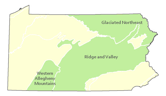
Pennsylvania Range
Allegheny Front and Deep Valleys Section of the Applachaian Plateau Region; Appalachian Mountain Section of the Ridge and Valley Region.
Global Distribution
New Jersey, New York, Pennsylvania, Virginia, and West Virginia.
Baker, M.E., and B.V. Barnes. 1998. Landscape ecosystem diversity of river floodplains in northwestern Lower Michigan, U.S.A. Canadian Journal of Forestry Research 28: 1405-1418.
Byers, E. A., J. P. Vanderhorst, and B. P. Streets. 2007. Classification and conservation assessment of high elevation wetland communities in the Allegheny Mountains of West Virginia. West Virginia Natural Heritage Program, West Virginia Division of Natural Resources, Elkins.
Cowardin, L.M., V. Carter, F.C. Golet, and E.T. La Roe. 1979. Classification of wetlands and deepwater habitats of the United States. U.S. Fish and Wildlife Service. Washington, D.C. 131 pp.
Edinger, Gregory J., D.J. Evans, Shane Gebauer, Timothy G. Howard, David M. Hunt, and Adele M. Olivero. 2002. Ecological Communities of New York State. Second Edition. A revised and expanded edition of Carol Reschke's Ecological Communities of New York State. New York Natural Heritage Program, New York State Department of Environmental Conservation. Albany, NY. 136 pp.
Fike, J. 1999. Terrestrial and palustrine plant communities of Pennsylvania. Pennsylvania Natural Diversity Inventory. Harrisburg, PA. 86 pp.
Gregory, S.V., F.J. Swanson, W.A. McKee, and K.W. Cummins. 1991. An ecosystem perspective of riparian zones. Bioscience 41: 540-551.
NatureServe. 2009. International Ecological Classification Standard: International Vegetation Classification. Central Databases. NatureServe, Arlington, VA. Available http://www.natureserve.org/explorer.
NatureServe. 2009. NatureServe Central Databases. Arlington, Virginia. USA
Pennsylvania Department of Conservation and Natural Resources (DCNR). 1999. Inventory Manual of Procedure. For the Fourth State Forest Management Plan. Pennsylvania Bureau of Forestry, Division of Forest Advisory Service. Harrisburg, PA. 51 ppg.
Pennsylvania Natural Heritage Program. 2004. Classification, Assessment and Protection of Non-Forested Floodplain Wetlands of the Susquehanna Drainage. Report to: The United States Environmental Protection Agency and the Pennsylvania Department of Conservation and Natural Resources, Bureau of Forestry, Ecological Services Section. US EPA Wetlands Protection State Development Grant no. CD-98337501.
Stone, B., D. Gustafson, and B. Jones. 2006 (revised). Manual of Procedure for State Game Land Cover Typing. Commonwealth of Pennsylvania Game Commission, Bureau of Wildlife Habitat Management, Forest Inventory and Analysis Section, Forestry Division. Harrisburg, PA. 79 ppg.
Ward, J.V. 1998. Riverine landscapes: Biodiversity patterns, disturbance regimes, and aquatic conservation. Biological Conservation 83: 269-278.
Zimmerman, E., and G. Podniesinski. 2008. Classification, Assessment and Protection of
Floodplain Wetlands of the Ohio Drainage. Pennsylvania Natural Heritage Program, Western Pennsylvania Conservancy, Pittsburgh, PA. Report to: The United States Environmental Protection Agency and the Pennsylvania Department of Conservation and Natural Resources, Office of Conservation Science. US EPA Wetlands Protection State Development Grant no. CD-973081-01-0.
Cite as:
Zimmerman, E. 2022. Pennsylvania Natural Heritage Program. Hairy-fruit Sedge (Carex trichocarpa) Floodplain Wetland Factsheet. Available from: https://naturalheritage.state.pa.us/Community.aspx?=30009 Date Accessed: July 09, 2026