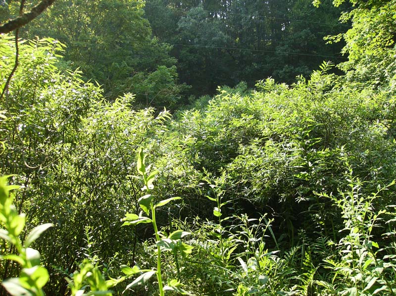
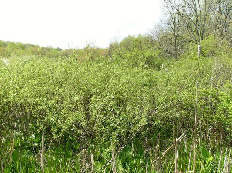
Black Willow Floodplain Thicket
System: Palustrine
Subsystem: Shrubland
PA Ecological Group(s): River Floodplain
Global Rank:GNR
![]() rank interpretation
rank interpretation
State Rank: S4
General Description
This community is found in the lower portion of the Susquehanna River watershed on the downstream ends of small and large islands in the river’s main stem and along back channels where sediment deposition occurs. This type also occurs in the slackwater wetlands behind dams. These areas are likely to experience lower stream velocity than vegetation types on island heads. Due to the reduced stream velocity, the substrates characteristic of this community tend to contain predominantly silt, sand, clay, and loam, with little gravel and cobbles.
A dense tall shrub layer of black willow (Salix nigra) covering greater than 30% of the area characterizes this community. Other common tall shrubs include shining willow (Salix lucida ssp. lucida), river birch (Betula nigra), and silver maple (Acer saccharinum).
The herbaceous layer can be sparse or dense and contains common dodder (Cuscuta gronovii), jewelweed (Impatiens capensis), water-willow (Justicia americana), hedge bindweed (Calystegia sepium), false nettle (Boehmeria cylindrica), water smartweed (Persicaria amphibia), and other common herbaceous wetland species. Invasive species may include purple loosestrife (Lythrum salicaria) and garden loosestrife (Lysimachia vulgaris).
Rank Justification
Uncommon but not rare; some cause for long-term concern due to declines or other factors.
Identification
- Dominated by black willow (Salix nigra)
- Occurs on the downstream ends of islands and back channels
- Substrate is silt, sand, clay and/or loam
Shrubs
Herbs
* limited to sites with higher soil calcium
Vascular plant nomenclature follows Rhoads and Block (2007). Bryophyte nomenclature follows Crum and Anderson (1981).
International Vegetation Classification Associations:
USNVC Crosswalk:None
Representative Community Types:
Willow River-Bar Shrubland (CEGL006065)
NatureServe Ecological Systems:
Central Appalachian Stream and Riparian (CES202.609)
NatureServe Group Level:
None
Origin of Concept
Zimmerman, E., and G. Podniesinski. 2008. Classification, Assessment and Protection of Floodplain Wetlands of the Ohio Drainage. Pennsylvania Natural Heritage Program, Western Pennsylvania Conservancy, Pittsburgh, PA. Report to: The United States Environmental Protection Agency and the Pennsylvania Department of Conservation and Natural Resources, Office of Conservation Science. US EPA Wetlands Protection State Development Grant no. CD-973081-01-0.
Pennsylvania Community Code*
SU : Black Willow Scrub/Shrub Wetland
*(DCNR 1999, Stone 2006)
Similar Ecological Communities
Black Willow Floodplain Thicket and Mixed Hardwood Floodplain Thicket both occur on islands but the Black Willow Floodplain Thicket occurs on the downstream sides of islands and the Mixed Hardwood Floodplain Thicket typically occurs on areas that receive more intensive flooding such as the head and middle portions of islands. The nearly pure dominance of black willow (Salix nigra) distinguishes Black Willow Floodplain Thicket from Mixed Hardwood Floodplain Thicket, which has a more diverse suite of species defining the shrub layer. Black Willow Floodplain Thicket differs from the Willow – Indian-grass Floodplain Shrub Wetland in that the former occurs on depositional sediment along lower velocity channels or on the downstream ends of islands while the latter occurs on sand and cobbles at the heads of islands and along scour zones.
Fike Crosswalk
Black willow scrub/shrub wetland
Conservation Value
The community is an important component of the river floodplain ecosystem, which provides significant ecosystem services such as sediment control, filtering runoff, and cooling overland flow of water. The shrublands provide habitat for rare insect species, namely ground beetles (order Carabidae) and others during the drier periods of the year.
Threats
Alteration to the frequency and duration of flood events and development of the river floodplains are the two greatest threats to this community statewide and can lead to habitat destruction and/or shifts in community function and dynamics. Development of adjacent land can lead to an accumulation of agricultural run-off, pollution, and sedimentation. Non-native invasive plants such as purple loosestrife (Lythrum salicaria) may displace native floodplain plants. Construction of flood-control and navigational dams have resulted in drastic changes to the timing and duration of flood events. These dams have, in some cases, slowed the river flow, resulting in the deposition of finer sediments favored by the invasive plants.
Management
Direct impacts to the floodplain ecosystems (e.g., road construction, development, filling of wetlands) have greatly altered their composition, structure, and function region-wide. Further impacts that alter riparian function of the remaining areas should therefore be avoided. When development is unavoidable, low impact alternatives (e.g., elevated footpaths, boardwalks, bridges, pervious paving) that maintain floodplain processes should be utilized to minimize impacts to natural areas and the plant and animal species within them. Maintenance of natural buffers surrounding high quality examples of floodplain wetlands is recommended in order to minimize nutrient runoff, pollution, and sedimentation. Care should also be taken to control and prevent the spread of invasive species into high quality sites, as Japanese knotweed (Fallopia japonica), giant knotweed (F. sachalinense), and purple loosestrife (Lythrum salicaria) may invade this community.
As floodplains are dependent on periodic disturbance, natural flooding frequency and duration should be maintained and construction of new dams, levees, or other in-stream modifications should be avoided. Activities resulting in destabilization of the banks or alteration of the disturbance patterns of the site should be avoided. Numerous land use planning recommendations have been proposed to reduce the negative impacts of changing land use on riparian systems. These include protecting riparian buffer habitat, retaining natural areas in developed landscapes, compensating for lost habitat, excluding livestock grazing from riparian areas, providing corridors between riparian and upland habitats, avoiding constructing roads and utility lines through riparian habitat areas, and restoring degraded riparian habitat. Free-flowing intact riparian systems provide a wide-range of ecological services that are expensive and difficult to replace through human intervention.
Research Needs
Variations may occur at eco-regional levels. There is need to assess and quantify soils, site hydrology, and other factors to further assess differences between these riverine shrublands.
Trends
There is little to suggest that the occurrence of this type is currently increasing or decreasing. Invasive plants able to tolerate flooded conditions may contribute to an overall reduction in quality region-wide. Wide-spread development of fertile floodplains in the past, particularly for agriculture, may have eliminated suitable habitat for this community.
Range Map
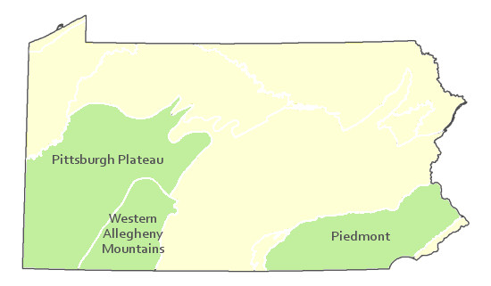
Pennsylvania Range
Western Allegheny Plateau, Central Applachian Forest, and Lower New England/Northern Piedmont
Global Distribution
Alabama, Arkansas, Florida, Georgia, Illinois, Kentucky, Louisiana, Maryland, Mississippi, North Carolina, Ohio, Oklahoma, Pennsylvania, South Carolina, Tennessee, Texas, Virginia, and West Virginia.
Pennsylvania Department of Conservation and Natural Resources (DCNR). 1999. Inventory Manual of Procedure. For the Fourth State Forest Management Plan. Pennsylvania Bureau of Forestry, Division of Forest Advisory Service. Harrisburg, PA. 51 ppg.
Stone, B., D. Gustafson, and B. Jones. 2006 (revised). Manual of Procedure for State Game Land Cover Typing. Commonwealth of Pennsylvania Game Commission, Bureau of Wildlife Habitat Management, Forest Inventory and Analysis Section, Forestry Division. Harrisburg, PA. 79 ppg.
Cite as:
Zimmerman, E. 2022. Pennsylvania Natural Heritage Program. Black Willow Floodplain Thicket Factsheet. Available from: https://naturalheritage.state.pa.us/Community.aspx?=30004 Date Accessed: July 09, 2026