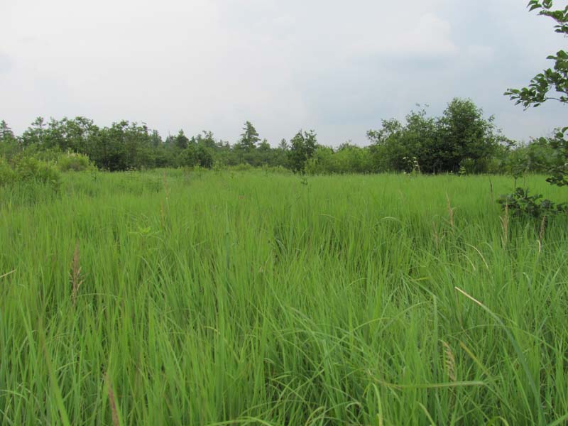
Bluejoint – Reed Canary-grass Marsh
System: Palustrine
Subsystem: Herbaceous
PA Ecological Group(s): Basin Wetland
Global Rank:GNR
![]() rank interpretation
rank interpretation
State Rank: S5
General Description
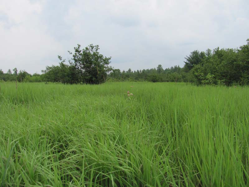
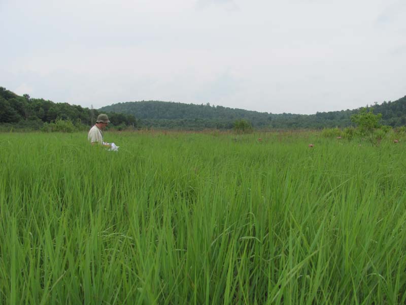
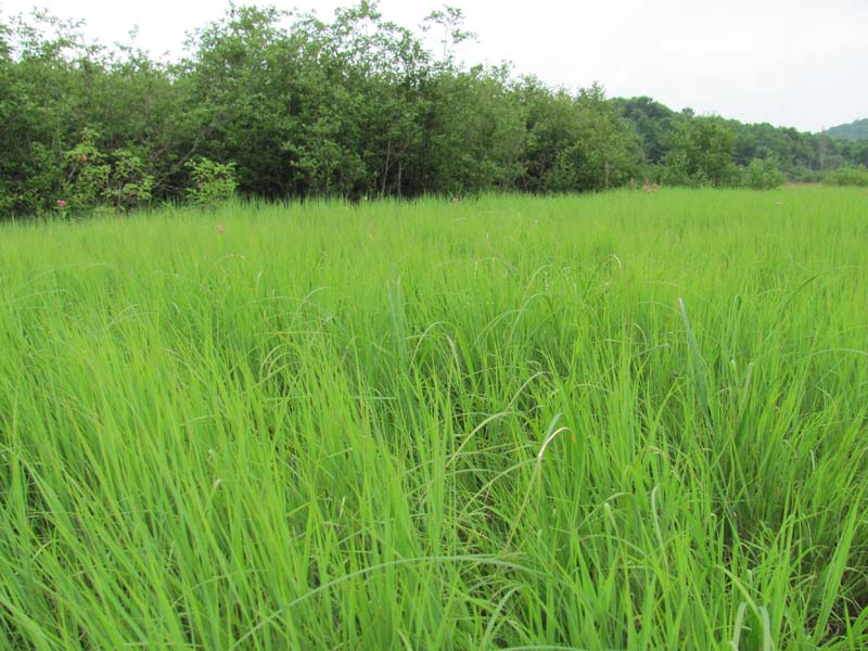
These marshes occur in a variety of landscape settings, from river backwaters to upland depressions. The most typical species are bluejoint (Calamagrostis canadensis var. canadensis) and reed canary-grass (Phalaris arundinacea). Associates vary widely, but commonly include mannagrass (Glyceria spp.), rice cutgrass (Leersia oryzoides), three-way sedge (Dulichium arundinaceum var. arundinaceum), Joe-Pye-weed (Eutrochium fistulosum, E. maculatum), common cat-tail (Typha latifolia), swamp dewberry (Rubus hispidus), wool-grass (Scirpus cyperinus) and other Scirpus spp. The invasive species, common reed (Phragmites australis ssp. australis), purple loosestrife (Lythrum salicaria), narrow-leaved cat-tail (Typha angustifolia) and Japanese knotweed (Fallopia japonica), are frequently a major problem in these systems.
Rank Justification
Common, widespread, and abundant in the jurisdiction.
Identification
- Dominated by bluejoint (Calamagrostis canadensis var. canadensis) and co-dominated by reed canary-grass (Phalaris arundinacea)
- Soils are typically mineral soil or well-decomposed peat, with a thick root mat
- Water regime varies between temporarily and seasonally flooded
- Graminoid cover is typically dense
Herbs
- Canada bluejoint (Calamagrostis canadensis var. canadensis)
- Reed canary-grass (Phalaris arundinacea)
- Rice cutgrass (Leersia oryzoides)
- Three-way sedge (Dulichium arundinaceum var. arundinaceum)
- Swamp dewberry (Rubus hispidus)
- Wool-grass (Scirpus cyperinus)
- Joe-pye weed (Eupatorium spp.)
- Cat-tail (Typha spp.)
Exotic Species
* limited to sites with higher soil calcium
Vascular plant nomenclature follows Rhoads and Block (2007). Bryophyte nomenclature follows Crum and Anderson (1981).
International Vegetation Classification Associations:
USNVC Crosswalk:None
Representative Community Types:
Bluejoint - Spotted Joe-pyeweed Herbaceous Vegetation (CEGL005174)
NatureServe Ecological Systems:
Great Lakes Coastal Wetlands Complex (CECX005702)
High Allegheny Wetland (CES202.069)
Central Appalachian River Floodplain (CES202.608)
North-Central Interior Wet Meadow-Shrub Swamp (CES202.701)
NatureServe Group Level:
None
Origin of Concept
Fike, J. 1999. Terrestrial and palustrine plant communities of Pennsylvania. Pennsylvania Natural Diversity Inventory. Pennsylvania Department of Conservation and Recreation, Bureau of Forestry, Harrisburg, PA. 86 pp.
Pennsylvania Community Code*
HB : Bluejoint – Reed Canary Grass Marsh
*(DCNR 1999, Stone 2006)
Similar Ecological Communities
Reed Canary-grass Floodplain Grasslands and Bluejoint – Reed Canary-grass Marsh communities may contain some similar species and occur in similar settings. The main distinguishing feature between the two communities is that Reed Canary-grass Floodplain Grasslands is almost completely dominated by reed canary-grass (Phalaris arundinacea) and Bluejoint – reed canary-grass marsh is co-dominated by bluejoint (Calamagrostis canadensis var. canadensis) and reed canary-grass. Tussock Sedge Marsh communities may contain reed canary grass and/or bluejoint but is strongly dominated by tussock sedge (Carex stricta). Bluejoint – reed canary-grass marsh may contain tussock sedge, but it is not dominant within the community. Sedge – Mixed Forb Fen and Bluejoint – Reed Canary-grass Marsh can be similar in appearance and environmental setting but Sedge – Mixed Forb Fen is strongly dominated by calciphilic species such as prairie sedge (Carex prairea), Atlantic sedge (Carex sterilis), sedge (Carex tetanica), and mountain-mint (Pycnanthemum virginianum). Mixed Forb – Graminoid Wet Meadow and Bluejoint – Reed Canary-grass Marsh can be similar in appearance and environmental setting but Mixed Forb – Graminoid Wet Meadow communities are dominated by a mixture of sedges (Carex spp.)and rushes (Juncus spp. and Scirpus spp.).
Fike Crosswalk
Bluejoint – Reed Canary-grass Marsh
Conservation Value
This community can serve as a buffer for sediment runoff and pollution from adjacent cleared or developed lands. Bluejoint – Reed Canary-grass Marsh communities can serve as important habitat for rare bird species such as sedge wrens (Cistothorus platensis), American bitterns (Botaurus lentiginosus), yellow-crowned night herons (Nyctanassa violacea), and black-crowned night herons (Nycticorax nycticorax).
Threats
Alteration to the hydrological regime and development are the major threats to this community (e.g., impoundments, beaver dams) and can lead to habitat destruction and/or shifts in community function and dynamics. Clearing and development of adjacent land can lead to an accumulation of agricultural run-off and pollution as well as sedimentation. Invasive plant species such as purple loosestrife (Lythrum salicaria), Japanese knotweed (Fallopia japonica), and common reed (Phragmites australis ssp. australis) can occur in this community.
Management
A natural buffer around the wetland should be maintained in order to minimize nutrient runoff, pollution, and sedimentation. The potential for soil erosion based on soil texture, condition of the adjacent vegetation (mature forests vs. clearcuts), and the topography of the surrounding area (i.e. degree of slope) should be considered when establishing buffers. The buffer size should be increased if soils are erodible, adjacent vegetation has been logged, and the topography is steep as such factors could contribute to increased sedimentation and nutrient pollution. Direct impacts and habitat alteration should be avoided (e.g., roads, trails, filling of wetlands) and low impact alternatives (e.g., elevated footpaths, boardwalks, bridges) should be utilized in situations where accessing the wetland can not be avoided. Care should also be taken to control and prevent the spread of invasive species within the wetland.
Research Needs
There is a need to collect plot data to characterize variations and guide further classification of this community.
Trends
These wetlands were probably more common but declined due to wetland draining/filling, hydrological alterations, and clearing of the adjacent lands leading to increased evaporation of the standing water and sedimentation. As a result, Reed Canary-grass Floodplain Grasslands and Common Reed Marsh may have replaced historic occurrences of Bluejoint – reed canary-grass marsh communities. The relative trend for this community is likely declining slightly due to hydrological alterations and invasion by exotic species.
Range Map
Pennsylvania Range
Statewide.
Global Distribution
Delaware, Maine, Massachusetts, Michigan, Minnesota, New York, Pennsylvania, Vermont, and Wisconsin.
Fike, J. 1999. Terrestrial and palustrine plant communities of Pennsylvania. Pennsylvania Natural Diversity Inventory. Harrisburg, PA.
NatureServe 2010. NatureServe Explorer: An online encyclopedia of life Version 7.1. NatureServe, Arlington, VA. Available http://www.natureserv.org/explorer (accessed: 23 November 2011).
Pennsylvania Department of Conservation and Natural Resources (DCNR). 1999. Inventory Manual of Procedure. For the Fourth State Forest Management Plan. Pennsylvania Bureau of Forestry, Division of Forest Advisory Service. Harrisburg, PA. 51 ppg.
Rhoads, Ann F. and Timothy A. Block. 1999. Natural Areas Inventory of Bucks County, Pennsylvania. Bucks County Commissioners, Doylestown, PA.
Rhoads, Ann F. and Timothy A. Block. 2005. Lackawanna State Park Vegetation Inventory. Report Submitted to DCNR, Bureau of State Parks.
Rhoads, Ann F. and Timothy A. Block. 2005. Varden Conservation Area Vegetation Inventory. Report submitted to DCNR, Bureauof State Parks.
Rhoads, Ann F. and Timothy A. Block. 2008. Natural Areas Inventory Update, Montgomery County, Pennsylvania. Montgomery County Planning Commission, Norristown, PA.
Stone, B., D. Gustafson, and B. Jones. 2006 (revised). Manual of Procedure for State Game Land Cover Typing. Commonwealth of Pennsylvania Game Commission, Bureau of Wildlife Habitat Management, Forest Inventory and Analysis Section, Forestry Division. Harrisburg, PA. 79 ppg.
Cite as:
Eichelberger, B. 2022. Pennsylvania Natural Heritage Program. Bluejoint – Reed Canary-grass Marsh Factsheet. Available from: https://naturalheritage.state.pa.us/Community.aspx?=16000 Date Accessed: July 09, 2026