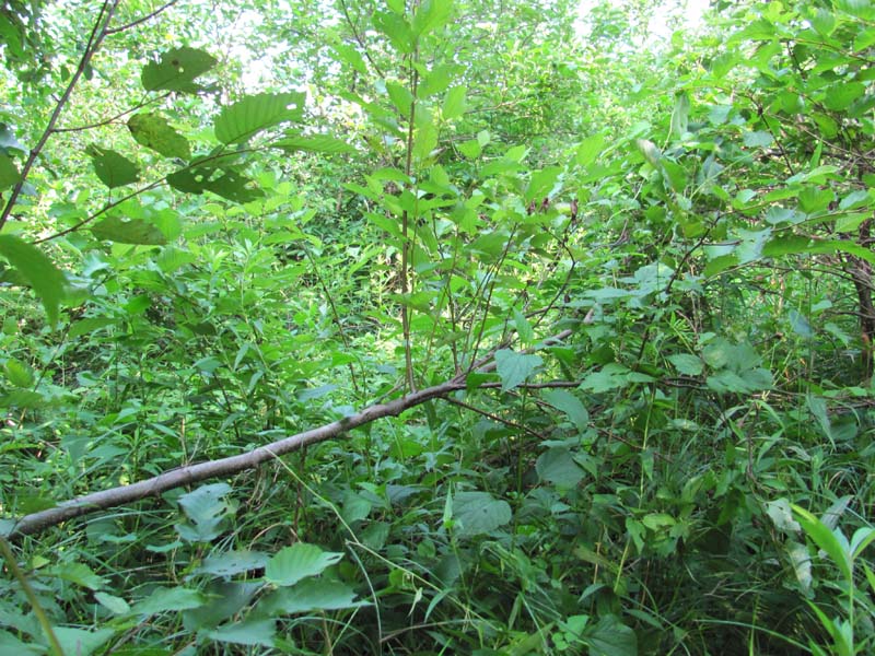
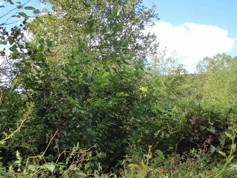
Alder – Dogwood Floodplain Thicket
System: Palustrine
Subsystem: Shrubland
PA Ecological Group(s):
River Floodplain
Global Rank:GNR
![]() rank interpretation
rank interpretation
State Rank: S4
General Description
This community occurs in the upper portions of the major drainages on smaller order streams. The Alder – Dogwood Riverine Shrubland is found on broad cobble flats or sand-over-cobble floodplain levees within the active channel, typically surrounded by and separated from the low-flow channel by the Periodically Exposed Shoreline Community. Alder – Dogwood Riverine Shrubland is subject to frequent flooding, high stream velocity, and ice scour since it occurs within the active stream channel.
The shrub component is moderately dense to dense and is dominated by speckled alder (Alnus incana ssp. rugosa), smooth alder (Alnus serrulata), black willow (Salix nigra), and silky dogwood (Cornus amomum). Steeplebush (Spiraea tomentosa), ninebark (Physocarpus opulifolius), sycamore (Platanus occidentalis), silky willow (Salix sericea), and silver maple (Acer saccharinum) are also commonly found. The moderately dense, diverse herbaceous layer contains many wetland species, such as reed canary-grass (Phalaris arudinacea), deer-tongue grass (Dichanthelium clandestinum), Virginia cutgrass (Leersia virginica), late goldenrod (Solidago gigantea), sedge (Carex intumescens), Virginia wild-rye (Elymus virginicus), gill-over-the-ground (Glechoma hederacea), wild germander (Teucrium canadense), tall meadow-rue (Thalictrum pubescens), big bluestem (Andropogon gerardii), muhly (Muhlenbergia spp.), Joe-Pye-weed (Eutrochium fistulosum), twisted sedge (Carex torta), violets (Viola spp.), boneset (Eupatorium perfoliatum), wild mint (Mentha arvensis), Allegheny monkey-flower (Mimulus ringens), and cleavers (Galium aparine). Riverbank grape (Vitis riparia) and virgin’s-bower (Clematis virginiana) are often found scattered throughout this community. This community is also susceptible to invasion by Japanese knotweed (Fallopia japonica), Japanese stiltgrass (Microstegium vimineum), and multiflora rose (Rosa multiflora).
Rank Justification
Uncommon but not rare; some cause for long-term concern due to declines or other factors.
Identification
- Dominated by alders and/or silky dogwood
- Growth of tree species is limited due to the flooding, high stream velocity, and ice scour to which these areas are frequently exposed
- Typically occurs within the active stream channel
- Substrate is usually cobble or sandy alluvium
- Maintained by annual episodes of high intensity flooding and ice scour
Shrubs
Herbs
- Reed canary-grass (Phalaris arundinacea)
- Deer-tongue grass (Dichanthelium clandestinum)
- Cutgrass (Leersia virginica)
- Smooth goldenrod (Solidago gigantea)
- Sedge (Carex intumescens)
- Virginia wild-rye (Elymus virginicus)
- Wild germander (Teucrium canadense)
- Tall meadow-rue (Thalictrum pubescens)
- Big bluestem (Andropogon gerardii)
- Joe-pye-weed (Eutrochium fistulosum)
- Twisted sedge (Carex torta)
- Violets (Viola spp.)
- Boneset (Eupatorium perfoliatum)
- Cleavers (Galium aparine)
- Muhly (Muhlenbergia spp.)
Exotic Species
* limited to sites with higher soil calcium
Vascular plant nomenclature follows Rhoads and Block (2007). Bryophyte nomenclature follows Crum and Anderson (1981).
International Vegetation Classification Associations:
USNVC Crosswalk:None
Representative Community Types:
Allegheny Floodplain Alder Thicket (CEGL006251)
NatureServe Ecological Systems:
Central Appalachian River Floodplain (CES202.608)
NatureServe Group Level:
None
Origin of Concept
Pennsylvania Natural Heritage Program. 2004. Classification, Assessment and Protection of Non-Forested Floodplain Wetlands of the Susquehanna Drainage. Report to: The United States Environmental Protection Agency and the Pennsylvania Department of Conservation and Natural Resources, Bureau of Forestry, Ecological Services Section. US EPA Wetlands Protection State Development Grant no. CD-98337501.
Pennsylvania Community Code*
SA : Hawthorn – Mixed Species Shrub Wetland
*(DCNR 1999, Stone 2006)
Similar Ecological Communities
Acidic Mixed Shrub – Sphagnum Wetland and Alder – Dogwood Floodplain Thicket can both be dominated by alders (Alnus spp.) but Acidic Mixed Shrub – Sphagnum Wetland is typically found in upland depression settings, contains sphagnum moss (Sphagnum spp.), and is generally more acidic. Alder – Dogwood Floodplain Thickets typically occur along active stream channels, lack sphagnum moss, and are circumneutral.
Mixed Hardwood Floodplain Thicket and Alder – Dogwood Floodplain Thicket contain similar species and occur along riverine settings. The main difference is that Mixed Hardwood Floodplain Thicket is dominated by a combination of species such as sycamore (Platanus occidentalis), silver maple (Acer saccharinum), eastern cottonwood (Populus deltoides), river birch (Betula nigra), and black willow (Salix nigra), but may be co-dominated by alders and the Alder – Dogwood Floodplain Thicket is clearly dominated by alders and dogwoods (Cornus spp.).
Fike Crosswalk
Alder - dogwood riverine shrubland
Conservation Value
The community is an important part of the river floodplain ecosystem, which provides significant ecosystem services in addition to wildlife habitat, such as sediment control, filtering runoff, and cooling overland flow of water. Floodplain shrublands provide important habitat for many bird species of conservation concern such as alder flycatchers (Empidonax alnorum), willow flycatchers (Empidonax traillii), and wood-warbler species (Parulidae spp.).
Threats
Alteration to the frequency and duration of flood events and the development of river floodplains are the two greatest threats to this community statewide and can lead to habitat destruction and/or shifts in community function and dynamics. Non-native invasive plants may be equally devastating as native floodplain plants are displaced. Development of adjacent land can lead to an accumulation of agricultural run-off, pollution, and sedimentation. This community can be threatened by Japanese knotweed (Fallopia japonica), Japanese stiltgrass (Microstegium vimineum), multiflora rose (Rosa multiflora), Morrow’s honeysuckle (Lonicera morrowii), and gill-over-the-ground (Glechoma hederacea), which can displace native grass and herb species.
Management
Direct impacts to floodplain ecosystems (e.g., channelization, road construction, development, filling of wetlands) have greatly altered their composition, structure, and function region-wide. Further impacts that alter riparian function of the remaining areas should be avoided. When development is unavoidable, low impact alternatives (e.g., elevated footpaths, boardwalks, bridges, pervious paving) that maintain floodplain processes should be utilized to minimize impacts to natural areas and the plant and animal species within them. Maintenance of natural buffers surrounding high quality floodplain wetlands is recommended to minimize nutrient runoff, pollution, and sedimentation. Care should also be taken to control and prevent the spread of invasive species into high quality sites. As floodplains are dependent on periodic disturbance, natural flood frequency and duration should be maintained and construction of new dams, levees, or other in-stream modifications should be avoided. Activities resulting in destabilization of the banks or alteration of the disturbance patterns of the site should be avoided. Numerous land use planning recommendations have been proposed to reduce the negative impacts of changing land use on riparian systems. These include protecting riparian buffer habitat, retaining natural areas in developed landscapes, compensating for lost habitat, excluding livestock grazing from riparian areas, providing corridors between riparian and upland habitats, avoiding construction of roads and utility lines through riparian habitat areas, and restoring degraded riparian habitat. In general, unaltered and intact river systems are more resilient to environmental stress than human-impacted or engineered river systems.
Trends
Alder – Dogwood Floodplain Thickets were undoubtedly more common historically and have declined due to dam impoundments, habitat conversion to agriculture or other development, and farming; modification of the adjacent upland has further impacted the quality of this type. The relative trend for this community is likely stable or may be declining slightly due to development; however, new alterations to river hydrology could result in significant changes to this type. High quality examples are most likely declining with the invasion of exotic plant species (e.g., Japanese knotweed (Fallopia japonica), Japanese stiltgrass (Microstegium vimineum), multiflora rose (Rosa multiflora)), lack of recruitment due to deer browse, and altered frequency and duration of flooding events.
Range Map
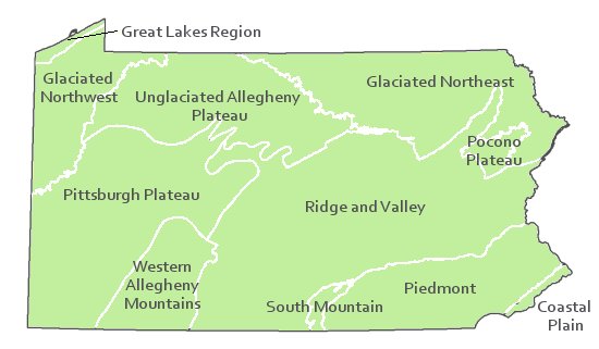
Pennsylvania Range
This type is found statewide.
Global Distribution
Maryland, New Hampshire, New York, Ohio, Pennsylvania, West Virginia, and potentially in Virginia.
Cowardin, L.M., V. Carter, F.C. Golet, and E.T. La Roe. 1979. Classification of wetlands and deepwater habitats of the United States. U.S. Fish and Wildlife Service. Washington, D.C. 131 pp.
Fike, J. 1999. Terrestrial and palustrine plant communities of Pennsylvania. Pennsylvania Natural Diversity Inventory. Harrisburg, PA. 86 pp.
NatureServe. 2009. International Ecological Classification Standard: International Vegetation Classification. Central Databases. NatureServe, Arlington, VA. Available http://www.natureserve.org/explorer.
Pennsylvania Department of Conservation and Natural Resources (DCNR). 1999. Inventory Manual of Procedure. For the Fourth State Forest Management Plan. Pennsylvania Bureau of Forestry, Division of Forest Advisory Service. Harrisburg, PA. 51 ppg.
Pennsylvania Natural Heritage Program. 2004. Classification, Assessment and Protection of Non-Forested Floodplain Wetlands of the Susquehanna Drainage. Report to: The United States Environmental Protection Agency and the Pennsylvania Department of Conservation and Natural Resources, Bureau of Forestry, Ecological Services Section. US EPA Wetlands Protection State Development Grant no. CD-98337501.
Stone, B., D. Gustafson, and B. Jones. 2006 (revised). Manual of Procedure for State Game Land Cover Typing. Commonwealth of Pennsylvania Game Commission, Bureau of Wildlife Habitat Management, Forest Inventory and Analysis Section, Forestry Division. Harrisburg, PA. 79 ppg.
Zimmerman, E., and G. Podniesinski. 2008. Classification, Assessment, and Protection of Floodplain Wetlands of the Ohio Drainage. Pennsylvania Natural Heritage Program, Western Pennsylvania Conservancy, Pittsburgh, PA. Report to: The United States Environmental Protection Agency and the Pennsylvania Department of Conservation and Natural Resources, Office of Conservation Science. US EPA Wetlands Protection State Development Grant no. CD-973081-01-0.

Cite as:
2022. Pennsylvania Natural Heritage Program. Alder – Dogwood Floodplain Thicket Factsheet. Available from: https://naturalheritage.state.pa.us/Community.aspx?=30001 Date Accessed: April 23, 2024