Sycamore Floodplain Forest
System: Palustrine
Subsystem: Forest
PA Ecological Group(s):
River Floodplain
Global Rank:GNR
![]() rank interpretation
rank interpretation
State Rank: S4
General Description
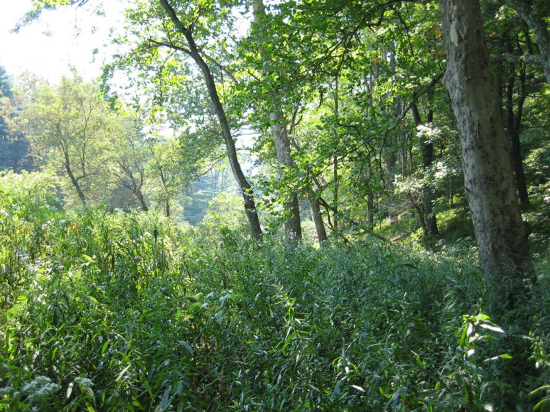
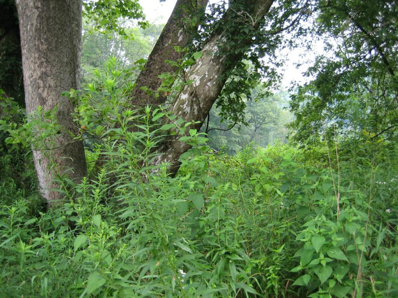
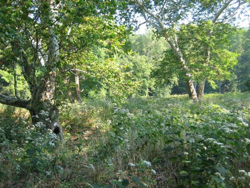
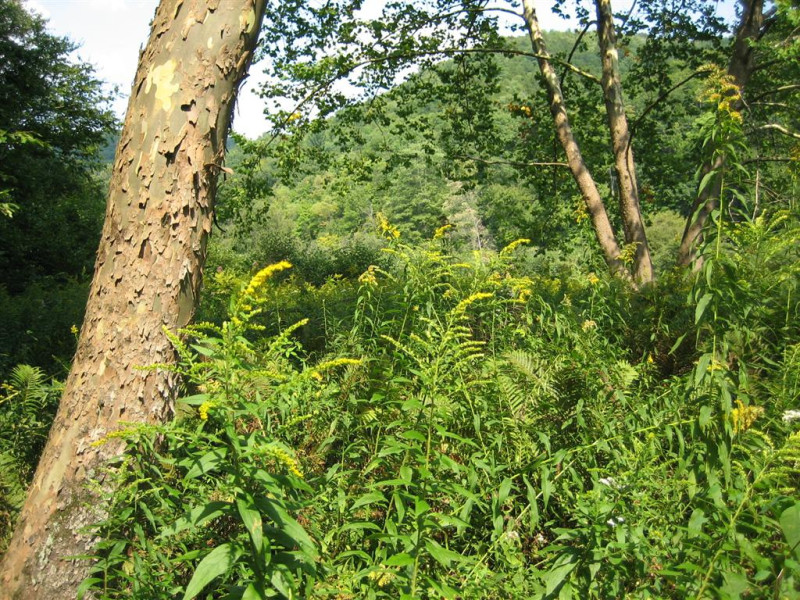
The Sycamore Floodplain Forest community typically occurs on the floodplains of intermediate to large order streams and rivers of the Ohio River basin, subject to extended periods of inundation, ice floe, and high velocity flood events. This type is found along higher gradient, smaller tributaries within the Susquehanna and Delaware River Basins. The sites supporting this type vary from islands, low bars, and cobble levees to low terraces and back channels (sloughs). The substrate may remain saturated or inundated for extended periods of time during the growing season. The substrate varies from well drained coarse sand, gravel, or cobble on bars, levees and islands in the stream channel to finer textured silt-loam of the sloughs and low terraces where flooding velocity is much reduced. The majority of stands appear to be roughly even-aged, suggesting the colonization of newly formed gravel/cobble bars after flood events. Where coarse sediment is accreting on the edge of existing sycamore stands, there may be several distinct cohorts of sycamore trees, with the oldest cohort furthest from the active stream channel. The community is characterized by a relatively open canopy dominated by sycamore (Platanus occidentalis). In the Ohio Basin, box-elder (Acer negundo) is often an important component of the understory. Silver maple (Acer saccharinum), is present, but not dominant, and river birch (Betula nigra), may be present in this type in the Susquehanna and Delaware River Basins. Other tree species include red ash (Fraxinus pennsylvanica), black walnut (Juglans nigra), black willow (Salix nigra), and black maple (Acer nigrum). Common shrubs include silky dogwood (Cornus amomum), gray dogwood (Cornus racemosa), ninebark (Physocarpus opulifolius), riverbank grape (Vitis riparia), and poison-ivy (Toxicodendron radicans). Herbaceous species diversity and cover varies greatly with the density of the canopy. On sites with a closed canopy, jewelweed (Impatiens spp.), clearweed (Pilea pumila), false nettle (Boehmeria cylindrica), wood-nettle (Laportea canadensis), great nettle (Urtica dioica), ostrich fern (Matteuccia struthiopteris), northern germander (Teucrium canadense), jumpseed (Persicaria virginiana), Jack in-the-pulpit (Arisaema triphyllum), and green dragon (Arisaema dracontium) are common. With a more open canopy, goldenrods (Solidago spp.), wingstem (Verbesina alternifolia), and riverbank wild-rye (Elymus riparius) dominate the herbaceous layer. The shrub and herbaceous layers are often heavily impacted by non-native plant species such as multiflora rose (Rosa multiflora), Morrow’s honeysuckle (Lonicera morrowii), common privet (Ligustrum vulgare), Japanese barberry (Berberis thunbergii), reed canary-grass (Phalaris arundinacea), stiltgrass (Microstegium vimineum), Japanese knotweed (Fallopia japonica), dame’s-rocket (Hesperis matronalis), and garlic mustard (Alliaria petiolata).
Rank Justification
Uncommon but not rare; some cause for long-term concern due to declines or other factors.
Identification
- Found throughout the Ohio River Basin on river floodplains of large creeks and rivers, but limited to higher gradient, smaller tributaries in the Susquehanna and Delaware River Basins.
- Canopy dominated by sycamore
- Substrate supporting younger stands sandy/cobbly, but finer sediments may be present in stands of larger trees.
- Large amounts of flood debris, suggesting community is influenced by high intensity flooding events
Trees
Shrubs
Herbs
- Jewelweed (Impatiens spp.)
- Clearweed (Pilea pumila)
- False nettle (Boehmeria cylindrica)
- Wood-nettle (Laportea canadensis)
- Stinging nettle (Urtica dioica)
- Wild germander (Teucrium canadense)
- Jack-in-the-pulpit (Arisaema triphyllum)
- Green-dragon (Arisaema dracontium)
- Goldenrods (Solidago spp.)
- Wingstem (Verbesina alternifolia)
- Riverbank wild-rye (Elymus riparius)
- Winterberry (Ilex verticillata)
- Northern arrow-wood (Viburnum recognitum)
- Highbush blueberry (Vaccinium corymbosum)
- Sedge (Carex intumescens)
- Sedge (Carex lurida)
- Short hair sedge (Carex crinita var. crinita)
- Marsh fern (Thelypteris palustris)
- Beggar-ticks (Bidens frondosa)
- Dotted smartweed (Persicaria punctata)
- Floating mannagrass (Glyceria septentrionalis)
- Bugleweed (Lycopus uniflorus)
- Jumpseed (Persicaria virginiana)
* limited to sites with higher soil calcium
Vascular plant nomenclature follows Rhoads and Block (2007). Bryophyte nomenclature follows Crum and Anderson (1981).
International Vegetation Classification Associations:
USNVC Crosswalk:None
Representative Community Types:
New River Sycamore - Ash Floodplain Forest (CEGL006458)
Piedmont / Central Appalachian Rich Floodplain Forest (CEGL004073)
Sycamore - Silver Maple Calcareous Floodplain Forest (CEGL007334)
NatureServe Ecological Systems:
Central Appalachian River Floodplain (CES202.608)
NatureServe Group Level:
None
Origin of Concept
Zimmerman, E., and G. Podniesinski. 2008. Classification, Assessment and Protection of Floodplain Wetlands of the Ohio Drainage. Pennsylvania Natural Heritage Program, Western Pennsylvania Conservancy, Pittsburgh, PA. Report to: The United States Environmental Protection Agency and the Pennsylvania Department of Conservation and Natural Resources, Office of Conservation Science. US EPA Wetlands Protection State Development Grant no. CD-973081-01-0.
Pennsylvania Community Code*
SE : Sycamore – (River Birch) – Box Elder Floodplain Forest
*(DCNR 1999, Stone 2006)
Similar Ecological Communities
Sycamore Mixed – Hardwood Floodplain Forest is the predominant sycamore-dominated floodplain forest type in eastern Pennsylvania and often co-dominated by river birch. Differences in soils, site hydrology, stream order and landscape position, and other ecosystem factors contribute to differences in species composition between the Sycamore Floodplain Forest and Sycamore Mixed – Hardwood Floodplain Forest type associated with the Susquehanna and Delaware River Basins. River birch, which is often a canopy co-dominant of Sycamore Mixed – Hardwood Floodplain Forest, is absent, or nearly so, in the Sycamore Floodplain Forest.
Fike Crosswalk
None. This type is new to the Pennsylvania Plant Community Classification developed from river floodplain classification studies in the Susquehanna and Ohio River Basins. It is related to the Sycamore - (river birch) - Box-elder Floodplain forest concept in Fike (1999), now separated into two types to reflect the near absence of river birch in the Ohio Drainage.
Conservation Value
The community is an important part of the river floodplain ecosystem, which provides significant ecosystem services such as sediment control, filtering runoff, and cooling overland flow of water, in addition to wildlife habitat,. Floodplain forests provide critical habitat for wildlife species. Abandoned oxbows, pools and depressions within the floodplain provide important breeding habitats for reptiles and amphibians. Great blue heron (Adrea herodias) nest in colonies on river floodplains near their riverine foraging areas. Standing dead trees (snags) provide cavities for bats, wood ducks (Aix sponsa), and other cavity nesting species. Large contiguous floodplain forests provide important habitat for wildlife species requiring large blocks of interior forest, such as neotropical migrants.
While this type itself is not rare in Pennsylvania, large contiguous forested floodplains along stretches of free flowing river are uncommon. Due to the widespread conversion to agriculture and development, large patches of floodplain forest are uncommon in Pennsylvania and hold high conservation significance.
Threats
Alteration to the frequency and duration of flood events and conversion of the river floodplains for human development are the two greatest threats to this community statewide and can lead to outright habitat loss and/or shifts in community function and dynamics. Invasion of non-native invasive plants may also be equally devastating as native floodplain plants are displaced. Development of the adjacent uplands can lead to increased pollution and sedimentation though increased run off.
Management
Direct impacts to the floodplain ecosystems (i.e. road construction, development, filling of wetlands) have greatly alter their composition, structure, and function region-wide. Further impacts that alter riparian function of the remaining areas should therefore be avoided. When development is unavoidable, low impact alternatives (i.e. elevated footpaths, boardwalks, bridges, pervious paving) that maintain floodplain processes should be utilized to minimize impacts to natural areas and plant and animal species within. Maintenance of natural buffers surrounding high quality examples floodplain wetlands is recommended in order to minimize nutrient runoff, pollution, and sedimentation. Care should also be taken to control and prevent the spread of invasive species into high quality sites.
As floodplains are dependent on periodic disturbance, natural flooding frequency and duration should be maintained and construction of new dams, levees or other in-stream modifications should be avoided. Activities resulting in destabilization of the banks or alteration of the disturbance patterns of the site should be avoided. Numerous land-use planning recommendations have been proposed to reduce the negative impacts of changing land use on riparian systems. These include: protecting riparian buffer habitat, retaining natural areas in developed landscapes, compensating for lost habitat, excluding livestock grazing from riparian areas, providing corridors between riparian and upland habitats, avoiding constructing roads and utility lines through riparian habitat areas, and restoring degraded riparian habitat. Providing the river system some scope to maintain itself may be more cost-effective in the long run than attempts at controlling natural functions through human intervention.
Research Needs
Variations occur at eco-regional levels. Plot data collected during floodplain studies to characterize floodplain communities indicated that Sycamore Floodplain Forests differ significantly between different drainages, most importantly, river birch (Betula nigra) shares dominance with sycamore in the Susquehanna drainage. Differences in soils, site hydrology, stream order and landscape position, and other factors contribute to differences in species composition between this type, primarily found in the Ohio Basin and the similar Sycamore – Mixed Hardwood Floodplain Forest type associated with the Susquehanna and Delaware River Basins, which includes the river birch as a canopy co-dominant. In addition to further studying the range of this type, there is need to monitor high quality examples of this community.
Trends
Sycamore Floodplain Forests were undoubtedly more common prior to wide-scale alteration of riverine ecosystems. Since European settlement this type has declined due to dam impoundments, human development, and farming; modification of the adjacent upland has further impacted the quality of this type. As this type requires high velocity flows, alteration of the natural flooding regime (duration and frequency) has most likely been the most critical factor influencing the quality and persistence of this type. The relative trend for this community is likely declining slightly due to development and further changes to river hydrology could(may?) result in significant changes to this type. High quality examples are most likely declining with invasion of exotic plant species, lack of recruitment due to deer browsing, and reduction in flooding frequency due to flood control and navigational dams.
Range Map

Pennsylvania Range
This type is most common in the Ohio River Basin in Pennsylvania, but is also found along higher gradient, smaller tributaries of the Susquehanna and Delaware Rivers.
Global Distribution
This community occurs throughout eastern and midwestern U.S. and has been identified in plant community classifications from New York west to Indiana.
Cowardin, L.M., V. Carter, F.C. Golet, and E.T. La Roe. 1979. Classification of wetlands and deepwater habitats of the United States. U.S. Fish and Wildlife Service. Washington, D.C. 131 pp.
Edinger, G. J., D.J. Evans, S. Gebauer, T.G. Howard, D. M. Hunt, and A. M. Olivero. 2002. Ecological Communities of New York State. Second Edition. A revised and expanded edition of Carol Reschke's Ecological Communities of New York State. New York Natural Heritage Program, New York State Department of Environmental Conservation. Albany, NY. 136 pp.
Fike, J. 1999. Terrestrial and palustrine plant communities of Pennsylvania. Pennsylvania Natural Diversity Inventory. Harrisburg, PA. 86 pp.
Khan, Nancy R., Ann F. Rhoads, and Timothy A. Block. 2005. Characterization and assessmant of the Floristic Resources in Evansburg State Park. Report submitted to DCNR, Bureau of State Parks.
Khan, Nancy R., Ann F. Rhoads, and Timothy A. Block. 2008. Vascular flora and community assemblages of Evansburg State Park, Montgomery County, Pennsylvania. Bulletin of the Torrey Botanical Club 135(3): 438-458.
NatureServe. 2009. NatureServe Central Databases. Arlington, Virginia. USA
Pennsylvania Department of Conservation and Natural Resources (DCNR). 1999. Inventory Manual of Procedure. For the Fourth State Forest Management Plan. Pennsylvania Bureau of Forestry, Division of Forest Advisory Service. Harrisburg, PA. 51 ppg.
Pennsylvania Natural Heritage Program. 2002. Classification, Assessment and Protection of Forested Floodplain Wetlands of the Susquehanna Drainage. Report to: The United States Environmental Protection Agency and the Pennsylvania Department of Conservation and Natural Resources, Bureau of Forestry, Ecological Services Section. US EPA Wetlands Protection State Development Grant no. CD-993731.
Rhoads, Ann F. and Timothy A. Block. 1999. Natural Areas Inventory of Bucks County, Pennsylvania. Bucks County Commissioners, Doylestown, PA.
Rhoads, Ann F. and Timothy A. Block. 2004. East Goshen Township Wetlands; Vegetation Inventory and Management Recommendations. Reoprt submitted to East Goshen Township, Chester County, PA.
Rhoads, Ann F. and Timothy A. Block. 2004. Lehigh Gorge State Park Natural Resource Inventory. Report submitted to DCNR, Bureau of State Parks.
Rhoads, Ann F. and Timothy A. Block. 2005. Jacobsburg Environmental Education Center Vegetation Inventory. Report submitted to DCNR, Bureau of State Parks.
Rhoads, Ann F. and Timothy A. Block. 2005. Lackawanna State Park Vegetation Inventory. Report Submitted to DCNR, Bureau of State Parks.
Rhoads, Ann F. and Timothy A. Block. 2008. Natural Areas Inventory Update, Montgomery County, Pennsylvania. Montgomery County Planning Commission, Norristown, PA.
Rhoads, Ann F. and Timothy A. Block. 2008. Vegetation of Ridley Creek State Park. Report submitted to DCNR, Bureau of State Parks.
Stone, B., D. Gustafson, and B. Jones. 2006 (revised). Manual of Procedure for State Game Land Cover Typing. Commonwealth of Pennsylvania Game Commission, Bureau of Wildlife Habitat Management, Forest Inventory and Analysis Section, Forestry Division. Harrisburg, PA. 79 ppg.
Zimmerman, E., and G. Podniesinski. 2008. Classification, Assessment and Protection of
Floodplain Wetlands of the Ohio Drainage. Pennsylvania Natural Heritage Program, Western Pennsylvania Conservancy, Pittsburgh, PA. Report to: The United States Environmental Protection Agency and the Pennsylvania Department of Conservation and Natural Resources, Office of Conservation Science. US EPA Wetlands Protection State Development Grant no. CD-973081-01-0.

Cite as:
Zimmerman, E. 2022. Pennsylvania Natural Heritage Program. Sycamore Floodplain Forest Factsheet. Available from: https://naturalheritage.state.pa.us/Community.aspx?=16025 Date Accessed: April 19, 2024